
 |
 |
 |
 |
 |
 |
 Bear Creek
Bear Creek
Bear Creek- Big Bear Flat Lassen Creek Pit River - Mason/Monchamp Pit River - Shaw Pit River - Rose Creek Putah Creek - Winters Park Trout Creek  Ash Creek
Pleasants Creek
Putah Creek
Ash Creek
Pleasants Creek
Putah Creek- Winters Park |
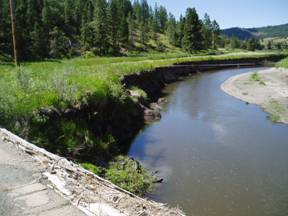
Pit River - Shaw Property The Pit Resource conservation District in cooperation with the local landowners has initiated a series of projects along the Pit River and tributaries in Modoc County California. These projects are intended to address resource and landowner concerns resulting from negative channel responses to past management practices. The Pit River is deeply incised in this region, probably as a result of some combination of past alterations including channelization, levees, over-grazing, irrigation dam construction and operation, and vegetation removal. The causal factors vary with location, but the end result has been a channel that is highly entrenched within eroding gully walls. The chronic collapse of the gully walls is symptomatic of incised channels that work to re-establish a functional floodplain at the lower elevation. Due to the insurmountable issues that would arise if the channel were returned to a functional connection with the surrounding agricultural floodplain, planning focused on stabilization techniques, rather than true restoration of the historic condition. To meet this objective of bank stabilization, StreamWise based project design on the current tendencies of the river to increase lateral floodplain expanse at the lower elevation. Rather than apply “hard engineering” techniques such as rip-rap to the vertical gully walls, StreamWise suggested projects that move in the direction of the natural recovery tendencies and expand the new floodplain surface. Coupled with this recommendation is the need to establish riparian vegetation to resist flood forces and lateral erosion. The following photos depict some of the techniques applied to the Pit River Stabilization Projects.
The photos above clearly indicate the effectiveness of the rock vanes to protect the new floodplain elevation bench, even on the outside meander of a river that saw flood flows eight feet over the surface of the new floodplain. The photos do not show the thick layer of sediment deposition left behind on the surface of the bench following the flood events. © 2011 Stream Wise . All rights reserved |
 Big Warm Springs
Little Warm Springs Edwards Creek Kirtch Wildlife Management Area Lockes Ranch West Fork Walker River  West Fork
Walker Creek Check Dams Ruby Lake National Wildlife Refuge  Sprague River Cole Property
 Sprague River
|
 8
8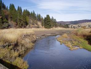 9
9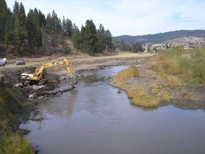 10
10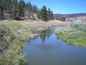 12
12